Map scale is one of those things that is easy to recognise without necessarily thinking much about what it means. Most walkers will have seen scales such as 1:25,000 and 1:50,000 printed on maps, but those numbers affect more than simply how much countryside fits onto the page. Scale influences how distance is represented, how much detail can be shown, and what features are available to use while navigating. Understanding it makes a map easier to interpret and helps explain why two maps of the same area can look very different.
What Map Scale Means
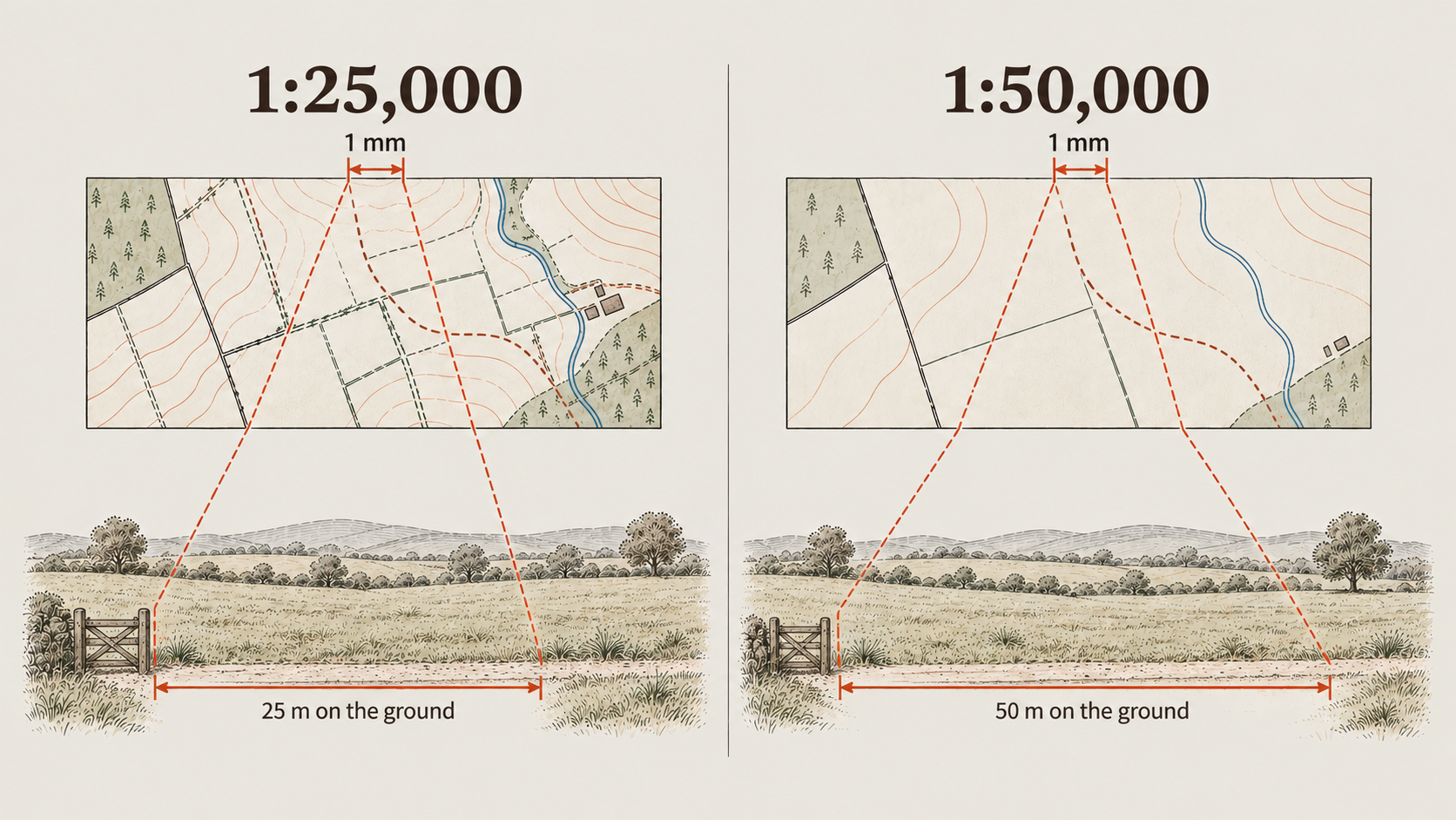
A map scale describes the relationship between a measurement on the map and the equivalent distance on the ground. On a 1:25,000 map, 1 mm on the map represents 25 m on the ground. On a 1:50,000 map, 1 mm represents 50 m on the ground.
That means the same measurement on a 1:50,000 map represents twice as much ground as it does on a 1:25,000 map. The difference affects more than distance. Because the same area of countryside occupies more space on a 1:25,000 map, smaller features can be shown in greater detail.
Understanding the Grid Lines
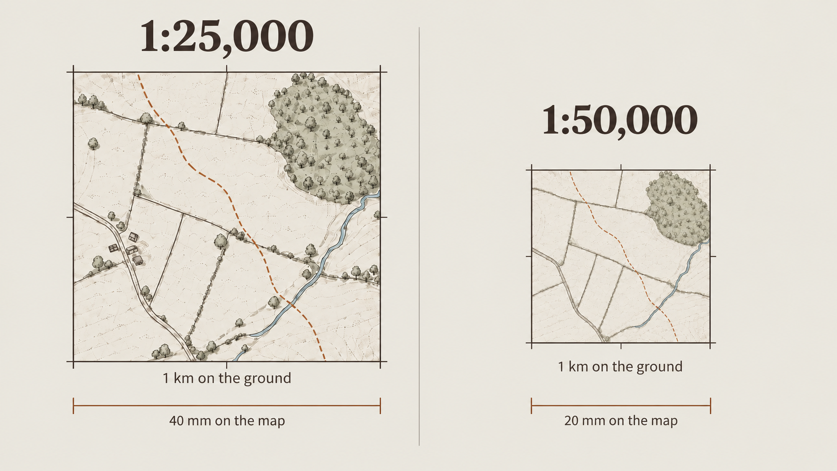
The grid printed across many walking maps provides another useful way to understand distance. On both 1:25,000 and 1:50,000 maps using a 1 km grid, the distance between neighbouring grid lines represents 1 kilometre on the ground.
What changes is the amount of space that kilometre occupies on the map. On a 1:25,000 map, adjacent grid lines are 40 mm apart. On a 1:50,000 map, they are 20 mm apart. The distance on the ground has not changed; the same kilometre has simply been represented within a smaller area of paper.
This also makes grid squares a useful visual reference when judging distance. Even without measuring precisely, knowing that each square represents one kilometre gives you an immediate sense of how far apart features are.
Why Scale Changes the Amount of Detail
At 1:25,000, smaller features have more space to be represented clearly. That allows features such as individual buildings, field boundaries, walls, small tracks, streams and woodland edges to be shown more clearly.
The advantage is not simply that the map looks more detailed. Those additional features can become useful navigation tools. A small building beside a track might confirm that you have reached the correct junction, a field boundary might provide a clear line to follow, and the edge of a wood might tell you when to change direction. The more features you can identify on both the map and the ground, the more opportunities you have to check that your position and direction still make sense.
Using Detail to Confirm Your Position
Good navigation rarely depends on a single feature. Instead, you can build confidence by comparing several things around you with what appears on the map.
A path junction may be accompanied by a nearby building, while a field boundary might meet the path at the same point and a small area of woodland could sit just beyond it. When several features match together, they provide stronger confirmation than relying on one landmark alone. A detailed map gives you more of these opportunities.
Handrail
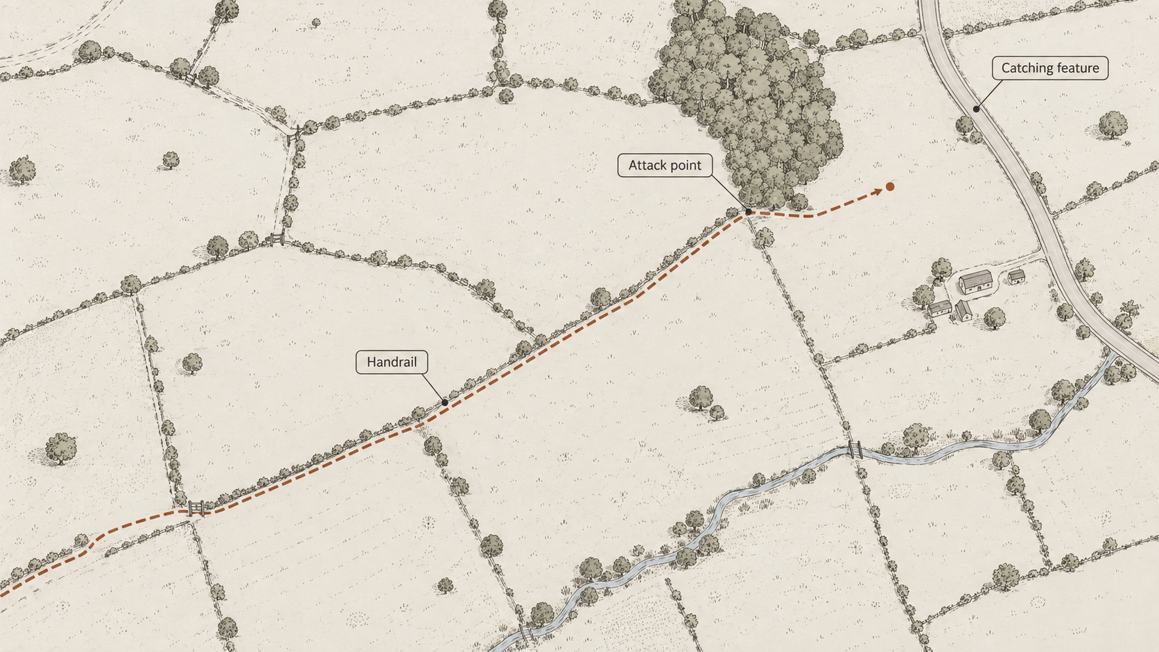
Some mapped features can also help guide you through the landscape. In navigation, a handrail is a linear feature that you can follow, such as a wall, fence, field boundary, stream, woodland edge or track.
Rather than relying entirely on a compass bearing across featureless ground, you may be able to use one of these features to keep yourself moving in the correct direction. A field boundary shown on the map might lead directly towards the next path junction, while a woodland edge could provide a clear line to follow until you reach a track. On a more detailed map, smaller features like these are often easier to identify and use.
Attack Point
A clear feature close to your destination can also provide a useful starting point for the final part of a navigation leg. This is often known as an attack point.
Instead of navigating directly towards a small or difficult-to-find feature, you might first aim for something easier to identify nearby, such as a field corner, bridge, path junction or woodland edge. Once you reach that feature, you can make the final approach from a known position. Detailed mapping can make these smaller features easier to identify in advance.
Catching Feature
A catching feature is something beyond your intended destination that tells you when you have travelled far enough. This might be a road, river, large track, woodland edge or another obvious feature.
If you are navigating towards a small path junction, for example, you might notice that a road lies a short distance beyond it. If you reach the road, you know you have gone too far. Thinking about catching features before you begin a navigation leg can make it easier to notice when something has gone wrong, and the amount of detail available on the map affects how many potential features you have to work with.
What a 1:50,000 Map Does Well
It can be tempting to assume that more detail automatically means a better map, but that is not always the case. A 1:50,000 map shows less fine detail, but its strength is that it gives you a broader view of the surrounding landscape.
More ground fits onto the same area of map, making it easier to see how larger features relate to one another. Ridges, valleys, rivers, roads, settlements and large areas of woodland may be easier to understand as part of the wider landscape rather than as isolated features.
Seeing the Shape of a Route
That broader view can be particularly useful when planning a longer walk. A 1:50,000 map can make it easier to see the overall direction of a route, where major climbs or descents occur, and how different parts of the landscape connect.
It may also make nearby alternatives easier to spot. If a route needs to be shortened, extended or changed, being able to see more surrounding countryside at once can help you understand what options are available. For route planning, that wider context can be just as useful as fine detail.
Navigating with Larger Features
Not every walk requires navigation by individual buildings and field boundaries. In open country, it may be more useful to think in terms of larger features such as ridges, valleys, rivers, major tracks and large areas of woodland.
A 1:50,000 map can work particularly well in this kind of landscape because it keeps those larger relationships clear. Rather than concentrating on every small feature along the way, you can focus on the broader shape of the ground and the main features that define your route.
A Less Cluttered View
Showing less detail can sometimes make a map easier to read. A highly detailed map contains more information, but that can also make it visually busier. If your aim is to understand the broad structure of the landscape, a simpler representation can make the important features stand out more clearly.
This is one reason why different scales can be useful at different stages of a walk. One may help with detailed navigation on the ground, while another gives a clearer view of the bigger picture.
1:25,000 or 1:50,000?
Neither scale is automatically the right choice for every walk. A 1:25,000 map can be particularly useful in areas where the path network is complex or where smaller features such as field boundaries, buildings and woodland edges provide useful navigation information.
A 1:50,000 map can be useful when planning a longer route, understanding the surrounding landscape or navigating primarily with larger features. The important thing is to understand what information each scale gives you. A more detailed map provides more features to work with, while a broader-scale view gives you greater awareness of how the surrounding landscape fits together.
Applying This on a Walk
Before starting a walk, take a moment to check the scale of the map you are using. On a 1:25,000 map, remember that 1 mm represents 25 m on the ground. On a 1:50,000 map, 1 mm represents 50 m. On maps using a 1 km grid, the distance between neighbouring grid lines represents 1 kilometre on the ground.
But scale is about more than measuring distance. Look at the features around your route and think about how they might help you navigate. A field boundary could act as a handrail, a building might confirm your position, a woodland edge could provide a catching feature, and a path junction might offer a reliable attack point. On a broader map, the shape of a ridge, valley or river may provide the clearest way to understand where you are going.
Once you understand what the scale is showing you, the map becomes more than a picture of the landscape. It becomes a collection of features that can help you move through it with greater confidence.