You stop beside a path, place your GPS device down and leave it untouched. A few minutes later, the recorded track looks like a tangled scribble, the reported accuracy has changed, or the device appears to have placed you in several slightly different locations.
Nothing has moved, so why has the position changed?
The important thing to understand is that a GPS device does not directly measure one fixed, perfectly accurate point. It continually calculates an estimated position from satellite signals, and that estimate can vary from one moment to the next.
What Is Happening?
A GPS receiver does not directly observe one fixed point on the ground. Instead, it repeatedly calculates an estimated position from signals transmitted by satellites orbiting above the Earth. Each satellite broadcasts the time at which its signal was sent, along with information about its position in orbit. Your device compares that transmission time with the moment the signal arrives and uses the tiny delay to estimate how far away the satellite is.
By combining measurements from several satellites, the receiver calculates where those distances intersect and produces a position. In ideal conditions, those measurements can be very accurate, but in the real world the signals do not always arrive perfectly. They may be delayed slightly as they pass through different layers of the atmosphere, while trees and foliage can weaken or scatter them. Steep slopes, cliffs and buildings can also restrict the receiver’s view of parts of the sky.
Signals may also reflect from nearby surfaces before reaching the receiver. This is known as multipath. Because a reflected signal has travelled farther than a direct one, the device may calculate the satellite as being slightly farther away than it really is, which can shift the final position.
The arrangement of the visible satellites matters as well. When satellites are spread widely across different parts of the sky, the device can usually calculate a stronger and more stable position. When they are clustered in a similar direction, small measurement errors can have a greater effect on the result. This is sometimes described as satellite geometry, and it means a device may be connected to plenty of satellites but still produce a less reliable position if those satellites are poorly distributed across the sky.
The satellites are also constantly moving in relation to the receiver. As their arrangement changes, some signals become stronger, others become weaker, and the device may begin using a slightly different combination of measurements. The receiver then produces a fresh position estimate every few seconds, or even more frequently, with each calculation reflecting the conditions at that particular moment.
One reading may place the device a few metres north of its true location, while the next may place it slightly west and another may move it closer again. If the device records each of these changing estimates as trackpoints, those points are joined together into a track. Over time, this can create a tangled scribble even though the receiver has remained completely stationary.
What You May Notice on a Walk
You are often most likely to notice GPS variation when standing still. While you are walking, small differences between individual position readings are spread along the direction of travel. They may appear as minor bends or irregularities in the recorded track and can easily go unnoticed. When you stop, however, there is no real movement for those variations to follow, so the changing position estimates begin to collect around the same area.
You might notice the position marker moving while you remain stationary, the displayed accuracy changing from one figure to another, or a cluster appearing in the recorded track. A waypoint may be saved several metres away from where you are standing, the recorded distance may continue to increase during a long stop, or several readings taken from the same spot may produce slightly different coordinates.
The effect may become more noticeable beneath dense tree cover, beside a steep hillside, close to cliffs or buildings, or anywhere else where the device has a restricted view of the sky. It can also happen in open terrain. Even with a clear view overhead, the device is still working with measurements that contain small uncertainties, and the arrangement of the satellites continues to change.
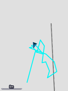
The device remained stationary, but changing position estimates produced this recorded track.
A small amount of apparent movement does not automatically indicate a problem with the device. It is a normal consequence of repeatedly calculating an estimated position.
Managing GPS Variation
For ordinary walking navigation, a small amount of position movement is rarely a serious problem. Rather than relying on the GPS marker alone to tell you exactly where you are, compare it with the path layout, nearby junctions, the direction you have travelled, surrounding terrain and visible landmarks.
At a path junction, for example, the shape and direction of the paths may tell you more than whether the position marker sits perfectly on top of the mapped line. If the device appears uncertain, allow it a little time to collect more readings. Moving into a more open area may also help if trees, terrain or buildings are restricting its view of the sky.
When recording an important feature, avoid assuming that the first saved waypoint is perfectly accurate. Some devices allow multiple samples to be combined through waypoint averaging, producing a more stable estimate of the location. Most importantly, treat the displayed position and accuracy figure as estimates rather than exact measurements.
An Example from the Field
Imagine you stop at a trig pillar and leave the GPS device resting beside it for several minutes. The first reading places the device slightly west of the pillar, while a later reading moves the position to the north and another places it closer to the mapped location.
As the device continues recording, these slightly different estimates are joined together. The resulting track forms a small tangled cluster around the pillar, despite the device never having moved. The shape of the scribble shows the variation between individual position fixes; it does not represent real movement around the site.
Applying This on a Walk
A GPS position is a calculated estimate rather than a perfectly fixed point. The device repeatedly measures satellite signals, and small variations in signal timing, atmospheric conditions, surrounding terrain and satellite geometry can alter each new position. That is why a stationary receiver may appear to move and why its recorded track can form a scribble.
For normal navigation, use the GPS position alongside the map, the terrain, the path layout and what you can see around you. When recording a location accurately matters, allow time for multiple readings and consider using waypoint averaging rather than relying on a single position fix.